Tijuana River Valley Cross-Border Research and Future Vision
The cross-border San Diego South Bay-Tijuana region is home to state parks, a Marine Protected Area (MPA), a federally sponsored National Estuarine Research Reserve (NERR), Navy bases, the Port of San Diego, recreational beaches, and vibrant border communities. Yet for decades impaired U.S. water quality has resulted in downstream health risks and economic impacts. The water quality impacts come from many sources including sewage released six miles south of the border in Punta Bandera and infrastructure failure in Tijuana that drains wastewater into the Tijuana River Estuary and coastal zone. Scripps Institution of Oceanography at UC San Diego has long been engaged in the region conducting research to understand these environmental issues, inform managers, and determine potential solutions to improve prediction and protect the public.
Scripps Oceanography maintains longstanding partnerships with government agencies and elected leaders. Scientists work hand in hand with federal, state, and local officials to understand and investigate environmental issues, and have a long history with the City of Imperial Beach, the County of San Diego Department of Environmental Health, and the State of California in establishing research pilot projects. As scientific understanding and monitoring technologies evolve, there is a vision to keep advancing this work to inform infrastructure decisions which would mitigate the issues and protect the community.
Scripps Oceanography Past and Current Research in the Cross-Border Region
San Diego Coastal Ocean Observing System: In 2002, Scripps Institution of Oceanography partnered with the City of Imperial Beach and the County of San Diego Department of Environmental Health through funding provided by the California Clean Beach Initiative to establish the first of its kind bi-national ocean observing system focused on the physics which drive coastal water quality. The system collected and analyzed bacterial levels in beach water samples in the context of ocean physical processes which transport impaired water quality. The study focused on historical analysis of fecal indicator bacteria data in comparison to ocean currents, rainfall amounts, and flows from the Tijuana Estuary, and leveraged near real-time high-frequency radar based maps of ocean currents that were collected continuously round the clock. Eventually the effort grew to become the Southern California Coastal Ocean Observing System (SCCOOS), a comprehensive ocean observing program that now spans the entire Southern California Bight and is part of the federal NOAA network. Three surface current measuring antennas – now part of the SCCOOS High Frequency Radar network – are located at Mexico’s Coronados Islands, the tip of Point Loma, and Border Field State Park, and have linked with radar antennas deployed south of the border.
Scientists: Eric Terrill, Lisa Hazard, Clarissa Anderson
Plume Tracking: In 2007, the International Boundary Water Commission (IBWC) sponsored a supplemental monitoring program as part of a federally mandated consent decree that aimed to identify and track plumes from the South Bay Ocean Outfall, characterize land-based sources with a focus on the Tijuana River, and identify the regional oceanographic conditions that lead to high concentrations of fecal indicator bacteria on South Bay beaches. The study detailed the frequency of pollution events and potential origin sources using novel robotic technology which was able to map the plumes of pollution. The report provided a formal set of monitoring recommendations to both the IBWC, Environmental Protection Agency, and San Diego Regional Water Quality Control Board. SCCOOS now maintains an operational Tijuana River Plume Tracker for the public to visualize the direction potential plume waters are moving relative to their discharge site. The role of the surfzone in transporting pollution was identified as an information gap in predicting the plume, and is now being addressed by Scripps scientists in more recent research projects.
Scientists: Eric Terrill, Bruce Cornuelle
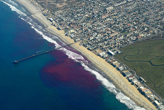
Cross Surfzone / Inner-shelf Dye Exchange Experiment and Current Modeling: In 2015 scientists from Scripps Oceanography performed a series of three experiments near Imperial Beach, Calif., releasing non-toxic bright pink fluorescent dye into beach waters to track the dye’s movements along the coast during south swell conditions. The released dye was a proxy for pollution. Researchers tracked it from the air, from research boats, on the shore, and underwater on both sides of the border. They found that the fate of the dye was strongly linked to the wave conditions. For example, during a day of strong south swell, the dye moved northward, staying close to shore for long periods of time and moving along the coastal surfzone at a speed of almost eight miles per day. This experiment also led to the development of a coupled ocean wave and circulation numerical model for the San Diego/Tijuana region from Point Loma to Rosarito, Mexico, and extending offshore to 120-foot depths. By looking at signals from freshwater and wastewater, scientists found wastewater contaminants at dilution levels of one-per-thousand to one-per-hundred per unit of water that propagate northward and southward depending on the wave direction – levels that the public would be advised not to swim in. The model they created allows scientists to evaluate how often and at what levels various coastal regions are impacted.
Scientists: Falk Feddersen, Sarah Giddings
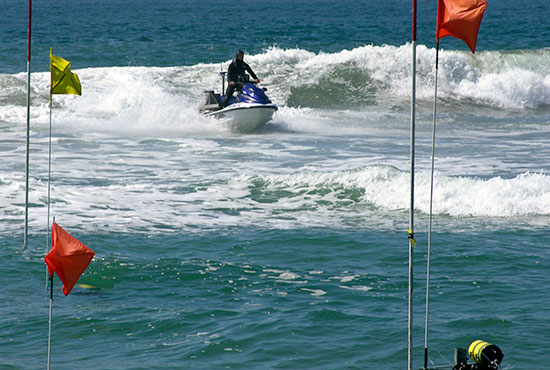
Monitoring Beach Change and Erosion Hot Spots: Scripps Oceanography has been studying wave-driven sediment transport near the Tijuana River mouth for more than a decade. Sand levels are monitored on-site using a truck-mounted scanning laser (lidar), and a sonar-equipped Jet Ski. Long-term trends in the sand level record show an erosion hotspot located in front of low-lying homes on Sea Coast Drive in Imperial Beach. The street is a site of recurring coastal flooding events. In September 2012, the beach in front of Sea Coast Drive was nourished with approximately 300,000 cubic meters of sand, enough to fill roughly 120 Olympic-sized swimming pools. Much of the nourishment sand migrated south and accumulated at the river mouth, likely contributing to the 2016 river mouth closure, which caused oxygen depletion in the water and hyper-polluted conditions in the estuary.
Scientists: Bonnie Ludka, Julia Fiedler, Mark Merrifield
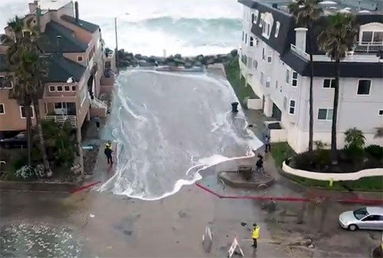
Resilient Futures Flood Alert System: In 2018, researchers with the Center for Climate Change Impacts and Adaptation (CCCIA) at Scripps developed a flood alert system customized to the needs of Imperial Beach. Due to its low-lying location, the city is considered one of the most vulnerable in California to sea-level rise. A network of instruments to measure local wave and water level conditions was installed to improve predictive models of coastal flooding, especially where large waves and extreme tides may occur simultaneously, exacerbating flooding risk. The goal is to arm city stakeholders with early flood warnings for vulnerable locations, and capture baseline information needed to develop and evaluate future sea-level rise adaptation strategies. This pilot program is now being adopted throughout the U.S.
Scientists: Mark Merrifield, James Behrens, Adam Young
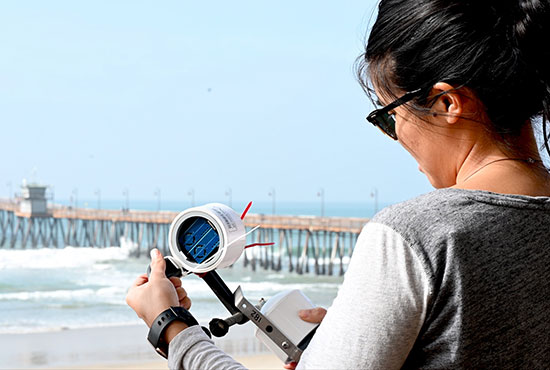
Aerosolization of Microbes from Wastewater: While it has been shown that contaminated water heavily impacts the San Diego coastal region, we know relatively little about how harmful compounds or pathogenic bacteria and viruses in wastewater become airborne once the sewage enters the surfzone, where sea spray aerosols are ejected from breaking waves. If harmful compounds and microbes are present in sufficient concentrations, vulnerable San Diegans should avoid coastal areas due to potential airborne exposure to pathogens. This project, using seed funding from UC San Diego’s Understanding and Protecting the Planet initiative, began in early 2019 and aims to characterize the air in the coastal zone of San Diego correlated with wind direction/speed and surfzone conditions; capture airborne, surf zone, and marine microbial communities; and quantify pathogen load. With it, researchers will inform decision makers of public health impacts before, during, and after storm events.
Scientist: Kimberly Prather
Vision for Future Research in the Region
Current proposals for infrastructure investments to mitigate transboundary flows of untreated wastewater are expected to reduce their frequency, but not fully prevent them, especially during high-impact storms. Infrastructure improvements also remain several years away. More monitoring is needed in the near and long term to protect people and mitigate the effects of wastewater flows, and determine baseline conditions so that an adequate assessment of the infrastructure programs can be assessed. Scripps Institution of Oceanography is well positioned to provide observations and modeling that can lead to real-time notifications that a hazardous event is occurring; critical data to link real-time observations with specific health risks; and predictions of future health risks. The net result will be less human illness and associated economic impacts, and a prediction system that can motivate infrastructure solutions to the region’s water quality problems.
In particular, water sampling and atmospheric monitoring systems are not adequate to fully inform the public of the hazards. Water quality sampling technologies still take up to 24- to 48-hours, which result in beach closures that potentially miss the worst water pollution. The timing of beach contamination events and closures are often misaligned, a problem emphasized two decades ago. Pollution plumes often hug the coast, yet an existing water quality prediction tool lacks nearshore information where humans directly contact the ocean. There is no adequate air monitoring system to observe and track infectious agents displaced by or ‘ejected in’ sea-spray aerosols during pollution events.
Scientists involved in this vision include Andrew Allen, Clarissa Anderson, Andrew Barton, Jeff Bowman, Bruce Cornuelle, Falk Feddersen, Sarah Giddings, Mark Merrifield, Kimberly Prather, Peter Rogowski, Uwe Send, and Eric Terrill.

Ocean Observations
There are significant gaps in ocean monitoring capabilities in the surfzone and nearshore, where most human exposure occurs. Further observational capabilities, studies, and model integration are needed to create more useful real-time predictive forecasts of where pollution is going for beaches in San Diego, Imperial Beach, and Coronado. Future ocean observations include:
- Water quality measurements in the inner shelf outside the surfzone with instruments attached to Imperial Beach Pier to measure temperature, salinity, chlorophyll fluorescence, and turbidity, or agitation of the water. Pollution is lower in salinity and higher in turbidity, and water samples could also measure hazards from microbes and harmful algal blooms (HABs).
- Low-cost shallow-water "mini-moorings" can be deployed via a small boat in depths of 2-30 meters. A variety of different sensors can be attached to the moorings, with the data sent automatically to shore from a small surface float. These sensors can easily measure temperature, salinity, and turbidity, or at a greater cost oxygen concentration, pH, currents, and nutrients. Of particular interest to wastewater detection is a sensor that measures a quantity related to biological oxygen demand (BOD), a measure of the amount of oxygen required to remove waste organic matter from water.
- Using new genetic technology to monitor ecosystem health, of which Scripps Oceanography is on the forefront in developing. By selectively sequencing specific taxonomic marker genes in the environment, we can build a comprehensive view of the composition of the microbial community. These include fecal indicators such as the enterococci, as well as members of the genus Bacteroides and other microbial taxa used in source tracking. These methods can help build a long-term record, and be extended to look for viruses.
Atmospheric Observations
Air quality monitoring and linking sea-spray aerosols with ocean conditions need more coverage in terms of seasonal and spatial variations in the region. Recent research has demonstrated sea spray aerosols carrying viruses and pathogens can be measured at least three miles inland, affecting the health of coastal and inland residents. Additional monitoring capabilities are needed to develop real-time predictive forecasts to provide warnings and safeguard the well-being of the general public. Examples include:
- A local meteorological station on the Imperial Beach and Scripps Institution of Oceanography Piers to examine atmospheric transport pathways. Coastal winds are complex and capturing additional detail in the immediate coastal area is critical.
- Aerosol measurements to assess toxins and pathogens, as well as atmospheric pathways, measurements of gas pollutants, particulate matter, bioparticles, and more are necessary to determine what is transferred into the atmosphere from the ocean and how far they can travel.
- Establishment of three atmospheric sampling sites at Imperial Beach Pier, Scripps Pier in La Jolla as a background ocean site, and an inland station atop Otay Mesa. The Otay Mesa site will assess inland transport from the coast and cross-border air pollution.
Ocean Pollution and Pathogen Modeling Systems
Scientists at Scripps Oceanography are developing the tools that can build a real-time model to predict the distribution of bacterial and viral pathogens, and a pollutant behavior model. The models will be validated with existing historical observations and near real-time pathogen detection methods. Implementation of these models and validating observations will greatly benefit coastal management, improve human health, limit economic impacts, and assess potential infrastructure solutions. The existing hindcast model for the ocean and estuary can be developed into a forecast model using the wastewater flow, wave, wind, and outer ocean forecasts. This model could make real-time forecasts up to one week in the future, and results can be included in an economic and risk decision analytic model to determine policies and infrastructure solutions.
Next Steps Towards Solutions
As decision makers identify permanent infrastructure solutions for the Tijuana River Valley, Scripps innovative modeling and sustained observations will be critical in validating the effectiveness of these efforts and the related impacts on human and environmental health. The development of a comprehensive plan that supports ocean, atmospheric, and pathogen observations and modeling is needed and paramount to the success of infrastructure improvements in this region.
For more information on Tijuana River Valley research conducted by Scripps Institution of Oceanography at UC San Diego, please contact scrippsgovrel@ucsd.edu.